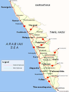
Kerala has 145,704 kilometers (90,536 mi) of roads (4.2% of India's total).  This translates to about 4.62 kilometers (2.87 mi) of road per thousand population, compared to an all India average of 2.59 kilometers (1.61 mi). Virtually all of Kerala's villages are connected by road. Traffic in Kerala has been growing at a rate of 10-11% every year, resulting in high traffic and pressure on the roads. Kerala's road density is nearly four times the national average, reflecting the state's high population density. Kerala's annual total of road accidents is among the nation's highest. India's national highway network includes a Kerala-wide total of 1,524 kilometers (947 mi), which is 2.6% of the national total. There are eight designated national highways in the state. The Kerala State Transport Project (KSTP), which includes the GIS-based Road Information and Management Project (RIMS), is responsible for maintaining and expanding the 1,600 kilometers (994 mi) of roadways that compose the state highways system; it also oversees major district roads. Most of Kerala's west coast is accessible through two national highways, NH 47, and NH 17. This translates to about 4.62 kilometers (2.87 mi) of road per thousand population, compared to an all India average of 2.59 kilometers (1.61 mi). Virtually all of Kerala's villages are connected by road. Traffic in Kerala has been growing at a rate of 10-11% every year, resulting in high traffic and pressure on the roads. Kerala's road density is nearly four times the national average, reflecting the state's high population density. Kerala's annual total of road accidents is among the nation's highest. India's national highway network includes a Kerala-wide total of 1,524 kilometers (947 mi), which is 2.6% of the national total. There are eight designated national highways in the state. The Kerala State Transport Project (KSTP), which includes the GIS-based Road Information and Management Project (RIMS), is responsible for maintaining and expanding the 1,600 kilometers (994 mi) of roadways that compose the state highways system; it also oversees major district roads. Most of Kerala's west coast is accessible through two national highways, NH 47, and NH 17.
 The state has three major international airports at Thiruvananthapuram, Kochi, and Kozhikode, that link the state with the rest of the nation and the world. The Cochin International Airport (COK) was the first Indian airport incorporated as a public limited company and is funded by nearly 10,000 Non Resident Indians from 30 countries. A fourth international airport is proposed at Kannur. The backwaters traversing the state are an important mode of inland navigation.National Waterway 3 traverse through the state. The Indian Railways' Southern Railway line runs throughout the state, connecting all major towns and cities except those in the highland districts of Idukki and Wayanad. Kerala's major railway stations are Trivandrum Central,, Kollam Junction, Chengannur, Kottayam, Ernakulam Junction, Thrissur Junction, Shoranur Junction, Palakkad, Kozhikode and Kannur. The state has three major international airports at Thiruvananthapuram, Kochi, and Kozhikode, that link the state with the rest of the nation and the world. The Cochin International Airport (COK) was the first Indian airport incorporated as a public limited company and is funded by nearly 10,000 Non Resident Indians from 30 countries. A fourth international airport is proposed at Kannur. The backwaters traversing the state are an important mode of inland navigation.National Waterway 3 traverse through the state. The Indian Railways' Southern Railway line runs throughout the state, connecting all major towns and cities except those in the highland districts of Idukki and Wayanad. Kerala's major railway stations are Trivandrum Central,, Kollam Junction, Chengannur, Kottayam, Ernakulam Junction, Thrissur Junction, Shoranur Junction, Palakkad, Kozhikode and Kannur.
 NATIONAM HIGHWAYS NATIONAM HIGHWAYS
NH 17: Panvel - Edappally >> Declared as NH in March 1972. Enters the State at Thalapadi and joins NH 47 at Edappally (Km 438/827). There are 26 major bridges and 28 minor bridges. Connecting Towns in Kerala -> Kasargod, Kanganad, Cheruthazum, Taliparambu, Kannur, Vadakara, Quilandy, Kozhikkode, Feroke, Ponnani, Perakam, Chavakkad, Thriprayar, Nattika, Paluvai, Kodungallur, Methala, Paravur, Kottuvally, Ernakulam (Edapally).
NH 47: Salem - Kanyakumari >> Enters the State at Walayar and leaves at Kalyikkavila. Total Length in Kerala : 416 km (167 km part of North-South and East-West Corridor (NS-EW; 7,300 km). Connecting Towns in Kerala -> Parasala, Neyyattinkara, Thiruvananthapuram city, Kazhakkuttam, Attingal, Chathannur, Kottiyam, Kollam, Karunagappally, Kayamkulam, Haripad, Ambalappuzha, Alappuzha, Cherthala, Aroor, Ernakulam, Aluva, Angamali, Koratty, Chalakudy, Thrissur (bypass), Mannuthy, Vadakkamchery, Alathur, Palakkad (bypass).
NH 49: Kochi - Madurai >> Declared as NH in February 1989. The National Highway 49 Enters the State at Bodimettu (km 119/017) and joins the NH 47 (Ending at Kundanoor (km 286/600) in Cochin Bypass.Three bypasses are to be constructed at Trippunithura, Muvattupuzha and Kothamangalam. This National Highway passes through the famous tourist centre at Munnar. From Bodimettu to Neryamangalam (km.200), it passes through the high ranges of western ghats. NH49 when properly established can connect cochin till rameshwaram-Dhanushkodi at the tip of bengal sea,very near to Another Country-Sri Lanka. Connecting Towns in Kerala -> Pettah Junction(Thrippunithura), Thiruvankulam, PuthenKuriz, Kolenchery, Muvattupuzha, Kothamangalam, Neriamangalam, Adimali, Munnar, Devikulam
NH 208: Kollam - Tirumangalam >> Declared NH in January 1999. Enters the State at Aryankavu and joins NH 47 at Kollam. There are 18 minor bridges and one major bridge.
NH 212: Kozhikode - Mysore >> Declared NH in July 1999. The entire section is from Kollegal to Calicut. Via Gundelpet - Sulthan Bathery, kalpetta, Vythiri, Tamaraserry. Enters the State at Muthanga and joins NH 17 at Kozhikode. Last 17 km in ghat section passes through forest land.
NH 213: Kozhikode - Palakkad >> Declared NH in July 1999. Starts from NH 17 at Kozhikode joins NH 47 at Palakkad
NH 220 : Kollam - Teni >> Declared NH in October 2000. The highway starts at Kollam on NH 47 and terminates at Teni on NH 49 in the State of Tamil Nadu.
STATE HIGHWAYS
There are 72 state highways in Kerala. Of them, MC Road (Main-Central Road) and Main Eastern Highway are the largest. The respective State Highway number is displayed on the top of all milestones (black in colour in green background) on the respective road.s |
 This translates to about 4.62 kilometers (2.87 mi) of road per thousand population, compared to an all India average of 2.59 kilometers (1.61 mi). Virtually all of Kerala's villages are connected by road. Traffic in Kerala has been growing at a rate of 10-11% every year, resulting in high traffic and pressure on the roads. Kerala's road density is nearly four times the national average, reflecting the state's high population density. Kerala's annual total of road accidents is among the nation's highest. India's national highway network includes a Kerala-wide total of 1,524 kilometers (947 mi), which is 2.6% of the national total. There are eight designated national highways in the state. The Kerala State Transport Project (KSTP), which includes the GIS-based Road Information and Management Project (RIMS), is responsible for maintaining and expanding the 1,600 kilometers (994 mi) of roadways that compose the state highways system; it also oversees major district roads. Most of Kerala's west coast is accessible through two national highways, NH 47, and NH 17.
 The state has three major international airports at Thiruvananthapuram, Kochi, and Kozhikode, that link the state with the rest of the nation and the world. The Cochin International Airport (COK) was the first Indian airport incorporated as a public limited company and is funded by nearly 10,000 Non Resident Indians from 30 countries. A fourth international airport is proposed at Kannur. The backwaters traversing the state are an important mode of inland navigation.National Waterway 3 traverse through the state. The Indian Railways' Southern Railway line runs throughout the state, connecting all major towns and cities except those in the highland districts of Idukki and Wayanad. Kerala's major railway stations are Trivandrum Central,, Kollam Junction, Chengannur, Kottayam, Ernakulam Junction, Thrissur Junction, Shoranur Junction, Palakkad, Kozhikode and Kannur.
 NATIONAM HIGHWAYS

